Research
Problem Statement

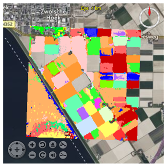
AI on geo data is receiving high attention currently. However, literature that AI models are primarily reliable on their training data (e.g., 85%) and drastically unreliable outside it (e.g., 20%). The illustration shows a field fruit classification in the Netherlands, applying a model produced by Wageningen Research. It is clearly visible how the model hallucinates over water (bottom left), providing incorrect results.
In this case, a geographical restriction (e.g., based on cadastral data) would already be sufficient to constrain the model to valid situations. However, in general the challenge can be of arbitrary complexity and often not decidable at all.
Currently, (i) there is no general method for characterizing the validity of models in terms of spatial, temporal, and content-based criteria; (ii) there is no method for using a validity characterization to protect specific user requests; and (iii) there is no method to automate these mechanisms within a general spatiotemporal geodata infrastructure. Published models – for example on HuggingFace with currently 827,859 models – at best have a textual description of their applicability, often overly optimistic and generic, and currently not machine-readable.
We summarize the capability of a server to recognize invalid data/model combinations and react appropriately as "model fencing" to express that AI models during their inference get constrained to their individual application conditions ("comfort zone"). FAIRgeo attempts to structure the field and find decision criteria for selected situations.
PS: we see the FAIRgeo interpretation of "FAIR" as compatible with the widely used expansion as "Findable, accessible, interoperable, reusable" - it is all about more usability and trust of (big) data.
News
Datacubes

Huh? Datacubes?
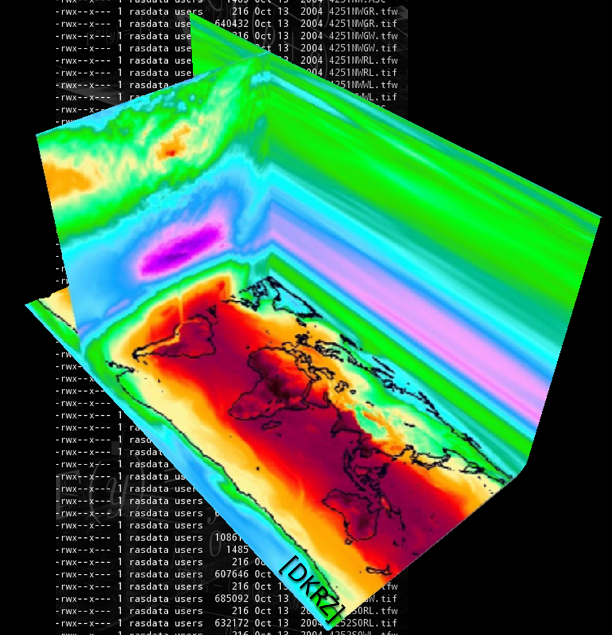
If you think about our atmosphere, do you think about zillions of NetCDF files? Probably not. You rather think of some 3D x/y/z space that changes over time - the fourth dimension, actually. Datacubes are intuitive and natural, simplifying wrangling of spatio-temporal data.
Multi-dimensional by Nature
Datacubes are not only 3D. They unify 1D sensor data, 2D imagery, 3D x/y/t image timeseries and x/y/z geological voxel data, 4D x/y/z/t atmospheric and ocean data, etc. Powerful, flexible standardized APIs as issued by OGC and ISO unify across all dimensions, simplifying access further.
Location-Transparent Federation
...establishes a single common information space where heterogeneous data sources feed homogenized datacubes for a flexible mix & match.
Curious? Try it Out!
Experience the award-winning, world-leading rasdaman datacubes hands-on with the Earth Datacube Playground!

About the Project
Project brief:
- Start: 01 Mar 2025
- Duration: 24 months
- Find us: fairgeo.org
- Funding information: Supported by EFRE Bremen


Project partners:
-
The Large-Scale Scientific Information Systems research group
at Constructor University
has worldwide reputation as pioneer of datacube services and Array Databases.
The group is actively shaping OGC, ISO, and INSPIRE datacube standards.

- rasdaman GmbH is the technology leader in high-performance Array Databases for flexible, scalable datacube services and, with Constructor University, shaper of the datacube standards. The proprietary rasdaman enterprise offers a unique combination of flexibility, scalability, federation, interoperability, green computing, and security.

Website Visitors
Terms of Reference
Responsible Maintainer
|
Constructor University Bremen gGmbH c/o Prof. Dr. Peter Baumann Campus Ring 12 28759 Bremen Germany |
Contact: Peter Baumann,
Image Credits
Images credits: Shutterstock, Constructor University.
No Operational Use
This service is for technology demonstration purposes only. No responsibility whatsoever is taken on availability of the service, availability of data at some particular location and time, and correctness of the data. It is explicitly forbidden to base decisions, such as choice of flight path, on this demonstration service.
External Links
All external links implemented on this site have been checked for conformance with the spirit and intent of this site, and have found conformant at this time. However, the maintainer of this site has no control over the (change of) contents of the referred websites and, therefore, does not assume any responsibility for the contents of referred websites.
German Data Protection Regulation (GDPR)
The controller responsible for the described data collection and processing is named in the Constructor University imprint.
When you visit our website, the Web server temporarily stores usage information on our server machine (running in Germany) for statistical purposes in the form of a log in order to improve the quality of our website and to fulfill funding agency statistics reporting obligations. We do not transfer your personal data to third parties without your express consent.
When it comes to processing your personal data, the GDPR grants you certain rights as a website user:
- Right of Access (Art. 15 GDPR): You have the right to request confirmation as to whether personal data concerning you is being processed; where this is the case, you have a right of access to this personal data and to the information specified in Article 15 GDPR.
- Right to Rectification and Right to Erasure (Art. 16 and 17 GDPR): You have the right to immediately request the rectification of incorrect personal data concerning you and, if necessary, the completion of incomplete personal data. You also have the right to request that personal data concerning you be erased immediately if one of the reasons listed in Art. 17 GDPR applies in detail, e.g. if the data is no longer required for the purposes for which it was collected.
- Right to Restriction of Processing (Art. 18 GDPR): You have the right to request a restriction of processing for the duration of a review if any of the conditions specified in Art. 18 GDPR have been met, e.g. if you have lodged an objection to the processing.
- Right to Data Portability (Art. 20 GDPR): In certain cases (which are outlined in detail in Article 20 GDPR), you have the right to obtain from us your personal data in a structured, standard, machine-readable format or to request the transfer of such data to a third party.
- Right to Object (Art. 21 GDPR): If data is collected on the basis of Art. 6(1)(f) GDPR (data processing on the grounds of legitimate interests), you have the right to object to the processing at any time for reasons arising from your particular situation. If you make such an objection, we will no longer process your personal data unless we can demonstrate compelling legitimate grounds for the processing which override your interests, rights, and freedoms or for the establishment, exercise, or defense of legal claims.
- Right to Lodge a Complaint with a Supervisory Authority In accordance with Art. 77 GDPR, you have the right to lodge a complaint with a supervisory authority if you believe that the processing of your personal data violates data protection regulations. This right to lodge a complaint may particularly be exercised before a supervisory authority in the EU member state where you reside, work, or where you suspect that your rights have been infringed.